The Fimmvörðuháls trail in Iceland is a 26km long including 1000m of climbing hike, one of the most spectacular trekking routes in Iceland, Europe (and even the world). The trail leads from Skogar to Thórsmörk and is located between the glaciers of Eyjafjallajökull and Mýrdalsjökull. Hiking around the world I can really say the route will leave you breathless. This trail is usually combined with Laugavegur trail, which leads from Thórsmörk to the famous Landmannalaugar.
The trail is usually done from north to south, but we decided to hike the whole 80-kilometer Laugavegur trail from Skogar to Landmannalaugar (south to north) in 4 days instead of 5. To be honest, as much as I love hiking, it was very exhausting.
Fimmvörðuháls trail is a real adventure.
Fimmvörðuháls trail is long and challenging, thus it is not crowded and not as popular as Laugavegur trail. But it is a real adventure and the landscapes are 100 times more spectacular than any other hikes in Iceland.
The Fimmvörðuháls trail is not for the faint of heart, it contains a series of challenging hiking stages that require endurance and strength. During the first day I fell down from the glacier, cutting my hands and hurting my knees.
Hiking Fimmvörðuháls trail laos requires some preparation – from booking a bus in advance, packing properly to physical conditioning.
Bus from Rekjavik to Skogar.
Most importantly you need to book a bus from Reykjavik to Skogar well in advance. There are only two buses a day and they are selling out quickly.
The bus runs from BSI – the main bus station in Reykjavik (that’s why it’s handy to stay in B47 Hostel, which is one of the most attractive places to stay in Reykjavik if you don’t want to spend a fortune and it’s only 10-minute walk from the BSI Station). They offer a great breakfast at a very good rate and cheap luggage storage.
The bus from Reykjavik to Skogar takes about 2.30-3h, depending on weather conditions. It stops just at the Skogafoss Waterfall, which is a pretty magic starting point 😉 and a great camping site.
- Reykjavík (Campsite Hostel) at 06:30am and
- Reykjavík (BSÍ Bus Terminal) at 07:00am.

We took a bus at 7am from BSI Bus Station in Reykjavik and arrived at Skogafoss Waterfall (parking and starting point) at 9.40am (photo above).
Fimmvorduhals trail is already challenging, so make sure you check the weather forecast before leaving on your journey. In my opinion, hiking this route in rainy conditions would be very difficult, slippery and unsafe.
The whole trail is well-marked, mostly with poles.
Best time to hike Fimmvörðuháls trail.
The best time to hike Fimmvörðuháls trail is from late spring to early autumn (June to September), when the trails are clear of snow and the weather is generally more stable.
We hiked in August and from what people and locals told us – we were unbelievably lucky it was only raining once during 4 days of the 80-kilometer hike. Temperatures during the day were 12-14 degrees Celsius and 5 degrees at night. However sleeping in the tent was fine, still wearing warm clothes and thick sleeping bag.
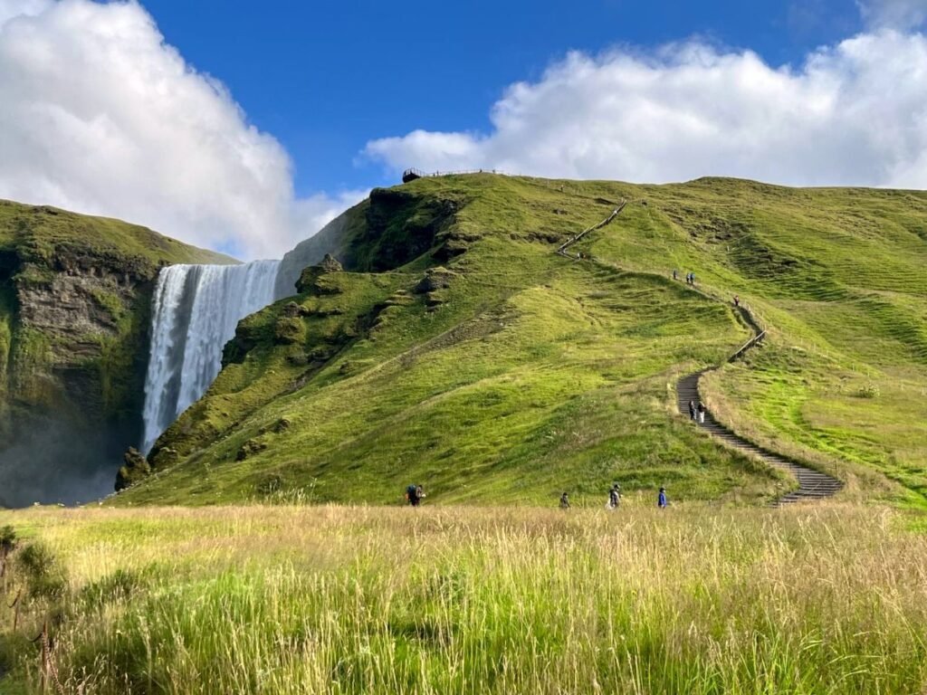
Skogafoss Waterfall - the starting point.
The trail begins with the powerful Skogafoss waterfall, a majestic sight that sets the tone for the adventure ahead. Once you get wet taking photos at the bottom of the waterfall you can start climbing the stairs to witness a magic rainbow that often appears on the top.
During the first half an hour of trekking the landscape transforms into moss-covered lava fields, as Iceland terrain is shaped by volcanic activity. There will be more than 20 spectacular waterfalls on your way, inviting you for some magnificent shots.
Fimmvorduhals trail summary:
DISTANCE: Approximately 26 kilometers (16 miles).
DURATION: It took us 10.5 hours. Typically takes 8 to 12 hours to complete, depending on fitness level and weather conditions.
ELEVATION GAIN: About 1,000 meters (3,280 feet) with stunning views.
STARTING POINT: Skogafoss Waterfall.
ENDING POINT: Thórsmörk (accessible by car).
NOTE: It’s much easier to hike from north to south. We did it the opposite way, so it was even more exhausting.
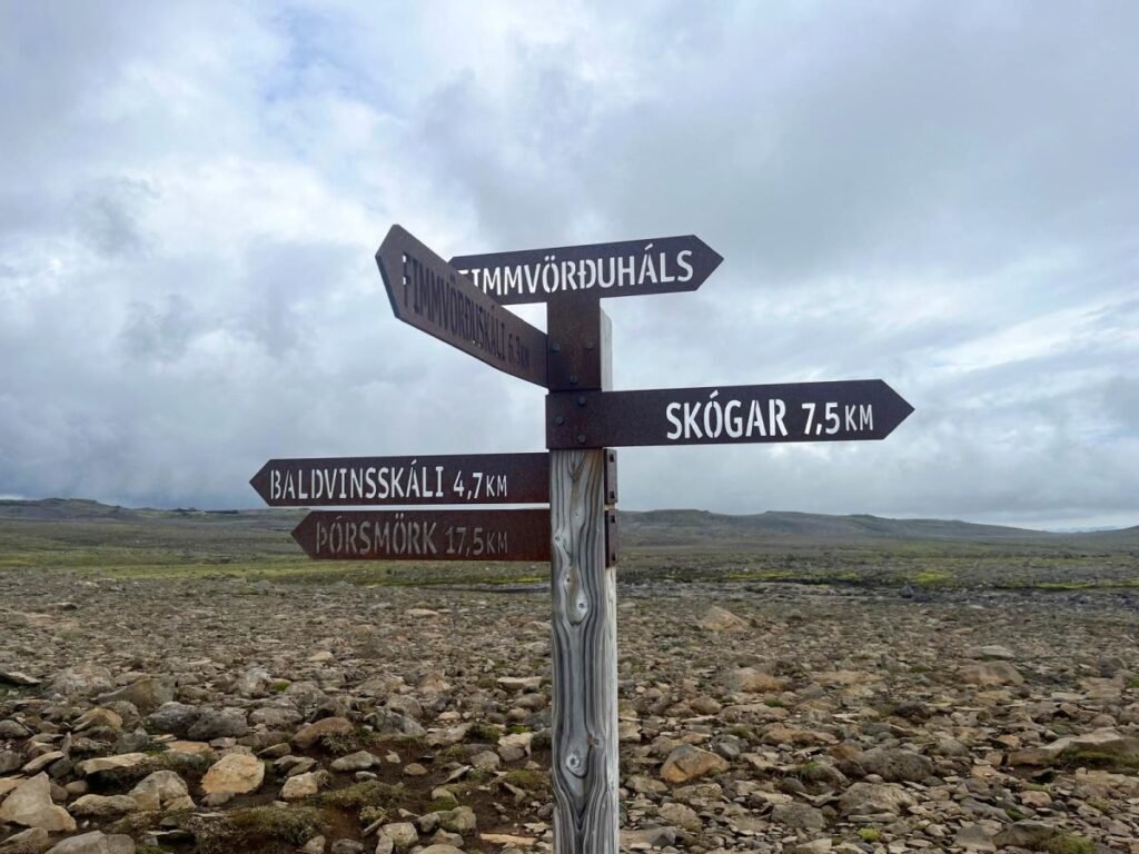
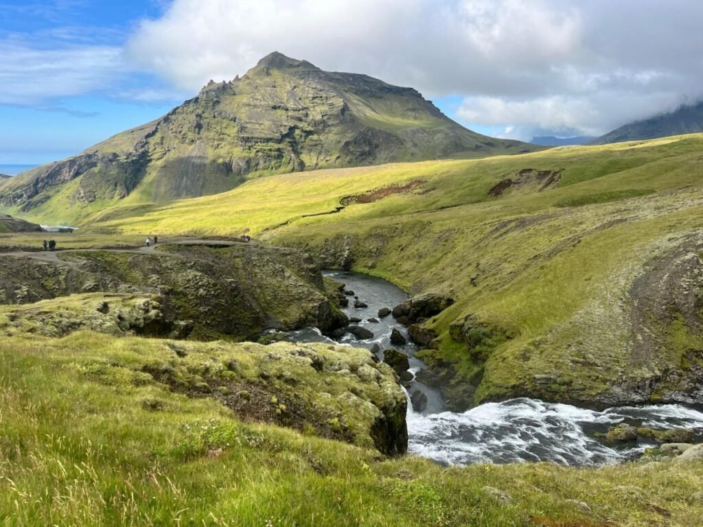
The second stage of the trail continues from Fimmvörðuskáli to Thórsmörk, guiding between the Myrdalsjökull and Eyjafjallajökull glaciers. Baldvinsskáli hut marks the first half of the trail (on the photo below). If you want to spend a night in the hut you should book it months in advance. We made a short stop for lunch in the hut, it’s possible to get some hot water indoor and hide from the wind.
From the hut, the trail goes through some tricky snowfields mixed with mud (this is where I fell hard 😉 ) just ahead of a steep gravel ascent, that will cost you some energy loss.
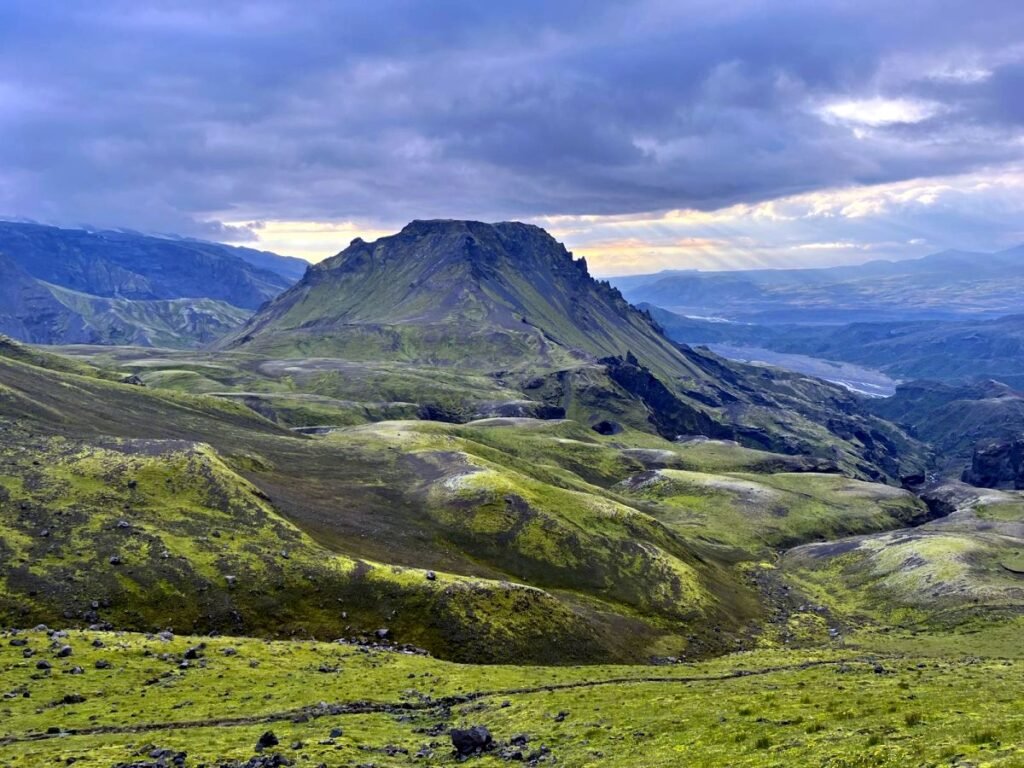
Cat's Spine Ridge.
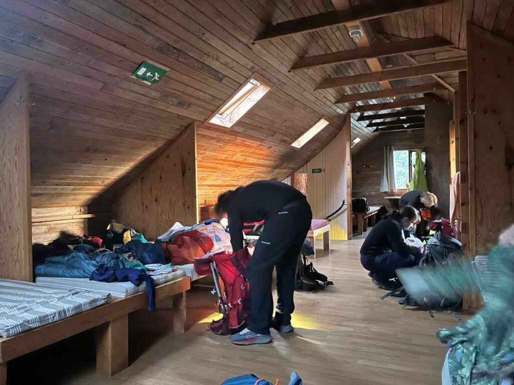
The final stage of the Fimmvörðuháls trail leads mostly throughthe valleys and marveling peaks. Although we were hiking with full equipment – tent, sleeping bags, food, etc. we booked a mountain hut in Basar. We thought we would be too tired to set up a tent after 26 kilometers of hiking and it was the best decision ever! Basar Hut is lovely, spacious and offers amazing facilities!
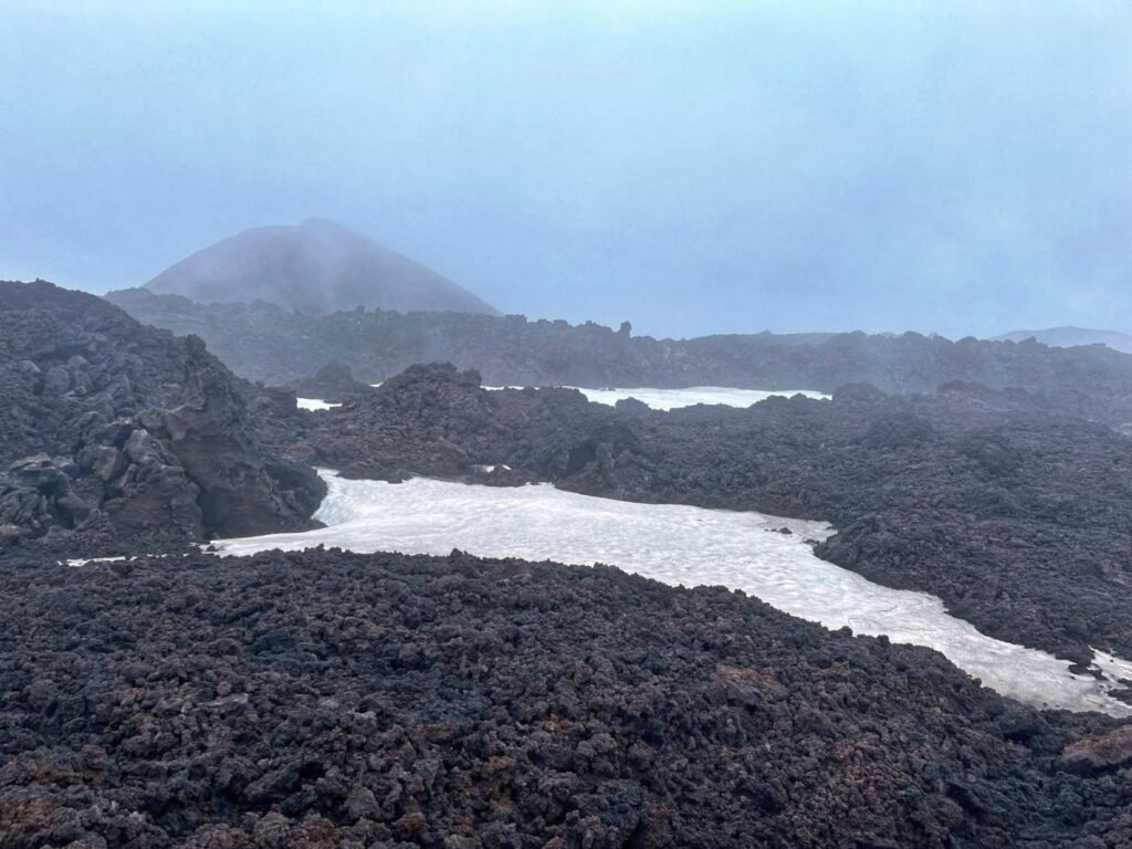
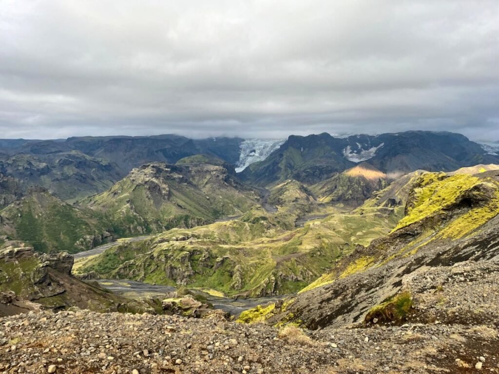
Just after the lunar landscape you are entering an amazing scenery overlooking Thorsmork valley.
If you think you’re done with the most challenging part – here comes the famous Cat’s Spine Ridge with a steep ascent along the chains and a narrow ridge.
After the Cat’s Spine Ridge the trail will surprise you with more stunning views. It was one of the most pleasurable stages of the trail along the sunset.
Basar hut.
And finally Basar hut! It was so lovely to shower and lay down in a warm bed. Basar hut is quite spacious and very comfortable, which means you don’t step on someone’s head. There are two cabins that can accommodate 55 people and 20 in the other one. We slept in the big one.
The next day we hit north to continue our hike. 5 minutes after start there are the first rivers to cross but make sure to get information about their condition before driving to Básar, as these rivers can be dangerous.
What to bring for Fimmvorduhals trail.
Weather in Iceland is the biggest challenge and it can be unpredictable. Check the forecast and be prepared for sudden changes.
- You need to carry a proper rain gear: windproof and waterproof jacket and bottoms are a must – wind and rain are the two biggest adversities of this adventure!
Good hiking boots, - Layers of clothing,
- Reusable bottle of water – you can use a filter or purifying tablets – but it’s not necessary in Iceland – the water is clean and drinkable.
- Thermos – I always carry a thermos, as hot ginger tea with lemon and honey is irreplaceable for me.
- Plenty of food – especially if you are on a longer hike – food is NOT accessible in every hut.
- Protein bars, chocolate, nuts, gel packs, isotonics.
- Water shoes – you will not be able to cross rivers without water shoes, the stony bottom of the river is slippery.
- First-aid kit – plasters, bandaids, pain killers, ibuprofen.
- Hiking poles are a must!
- Warm hat, gloves and sun glasses.
- Sun lotion – sun with strong wind can be very aggressive,
- Camera!
Note: This post may contain affiliate links, which are at absolutely no cost to you – I can earn a small commission on sales generated through this website and thanks to that I can share travel guides and inspirations that may help you reach your dream destinations and discover our unique world. I only recommend sites I actually use and have traveled to. Thank you for your support!


")
")
")
")